
Original text: Shayon Sengupta, Investment Partner at Multicoin Capital
Translation: Yuliya, PANews
The well-known cryptocurrency investment firm Multicoin announced on February 25 a strategic acquisition of $8 million worth of GEOD tokens from the Geodnet Foundation. It is reported that Geodnet is a precise positioning network that provides critical positioning services for drones, autonomous vehicles, and potentially a large number of robots in the future through the DePIN (Decentralized Physical Infrastructure Network) economic model.
The Era of Physical AI is Here
Although we have not yet reached the future scenario depicted in "Blade Runner 2049," where humanoid robots coexist with humans, by 2025, professional robots have quietly integrated into various aspects of modern life. Currently, language models are commercializing intelligence, unleashing new creativity and transforming the nature of knowledge work. However, the development of AI is not limited to text, images, and videos; its evolution is extending into the physical world, and robotics will become the next important frontier.
As the capabilities of AI models improve, their ability to understand and interact with the physical environment will significantly enhance. This shift will give rise to new types of autonomous systems, from autonomous vehicles and humanoid robots to drones and industrial automation equipment, which will operate with unprecedented intelligence and autonomy. For these robots to function, they must answer a fundamental question: Where am I?
Positioning: A $5 Billion Dilemma
As tens of millions of autonomous and semi-autonomous devices are deployed, they all face the same challenge: spatial awareness. Drone deliveries, autonomous vehicles navigating dense urban environments, and agricultural machines performing precise sowing all require sub-centimeter positioning accuracy to operate safely and efficiently.
To achieve such high precision, these systems rely on sensor fusion, combining various positioning methods.
- LiDAR can provide high-resolution depth mapping but performs poorly in foggy or rainy conditions (and has issues such as being heavy, power-hungry, and costly).
- RADAR provides robust distance measurements but lacks fine precision.
- Vision-based SLAM technology supports real-time mapping but significantly declines in performance in low-visibility environments.
Among the existing positioning solutions, GNSS (Global Navigation Satellite System) based systems combined with RTK (Real-Time Kinematic) base station corrections are recognized as one of the most reliable solutions.
Standard GNSS positioning has an inherent accuracy deviation of 5-10 meters due to atmospheric interference and multipath errors. RTK addresses this issue by using fixed base stations to compare satellite signals with known locations and transmit real-time correction data, achieving centimeter-level accuracy—crucial for physical AI applications. Currently, mainstream robotics and automation companies have integrated RTK into their systems:
- DJI for high-precision drones;
- John Deere for autonomous tractors;
- Tesla for autonomous vehicles;
- Boston Dynamics for industrial inspection robots.
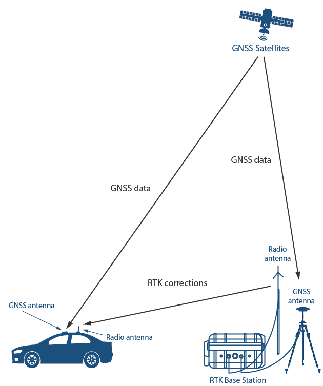
Image source: GNSS Store
However, RTK currently faces cost challenges. Building and maintaining RTK base stations requires significant capital investment, including hardware, site acquisition, and maintenance. Traditional suppliers like Trimble, Hexagon, and Topcon build their own base stations and charge thousands of dollars for each tracking device, limiting their accessibility and deployment speed. Coverage often concentrates in profitable areas, leaving many regions without access to high-precision positioning services.
Restructuring Cost Structures through DePIN
The contributor ownership model based on token incentives fundamentally restructures the cost structure of global hardware-intensive networks. As the world's largest precise positioning network, Geodnet leverages this principle to incentivize independent operators to install RTK base stations and provide correction data in exchange for token rewards.
By shifting the cost burden from a single operator to a distributed network, Geodnet can deploy production-grade RTK base stations at a cost far lower than traditional suppliers, primarily by eliminating the two major costs of network construction: land and labor. This enables Geodnet to expand coverage more quickly, ensure redundancy, and provide more reliable GNSS correction services than existing providers.
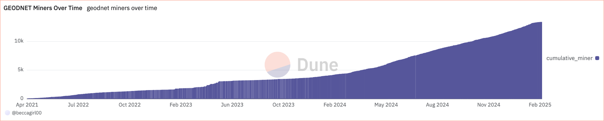
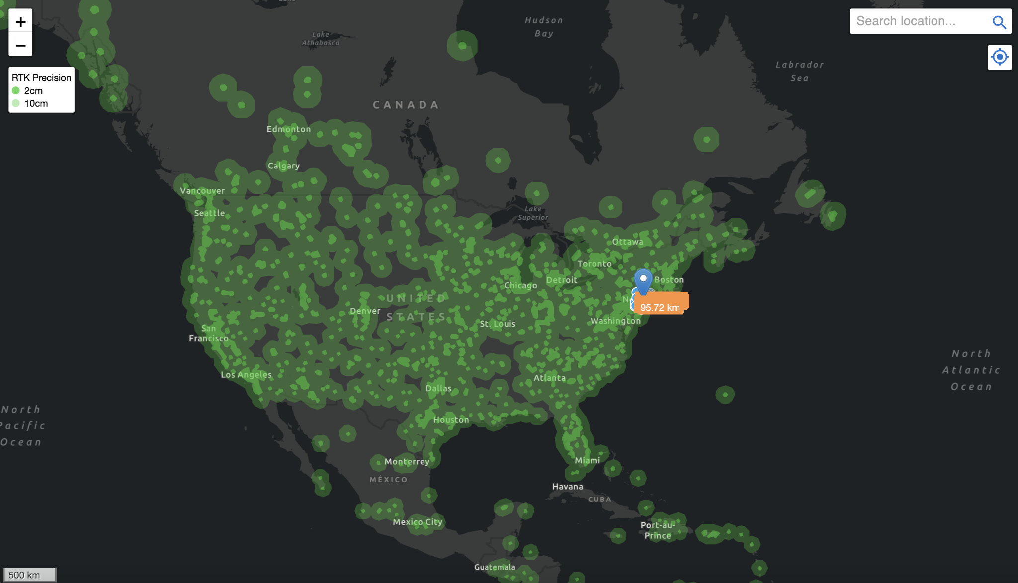
This model creates a globally distributed network that expands organically, significantly reducing end-user costs while ensuring service quality. Geodnet has rapidly expanded since last year, growing from 1,400 base stations in November 2022 to 7,800 by June 2024, and as of January 2025, it has over 13,000 base stations covering more than 4,377 cities in over 142 countries.
Currently, the Geodnet network has achieved "threshold scale," covering over 60% of the GNSS correction market. Notably, the network has achieved this supply with extremely high capital efficiency—only 11% of tokens have been issued to contributors over the past three years.
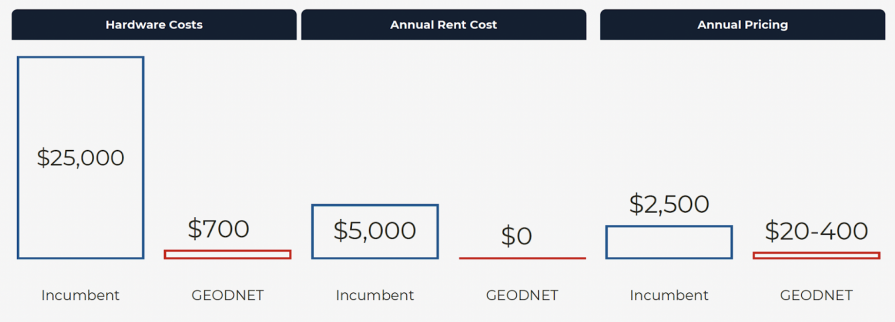
Geodnet is a prime example of the DePIN model in practice. The acquisition and deployment costs of Geodnet base stations have been reduced by an order of magnitude (consumer-grade mining machines at $700 vs. enterprise-grade RTK base stations at $12,000), and thanks to a denser consumer-grade network deployment, annual pricing has also significantly decreased. Geodnet is undoubtedly the most scalable and cost-competitive positioning solution available today.
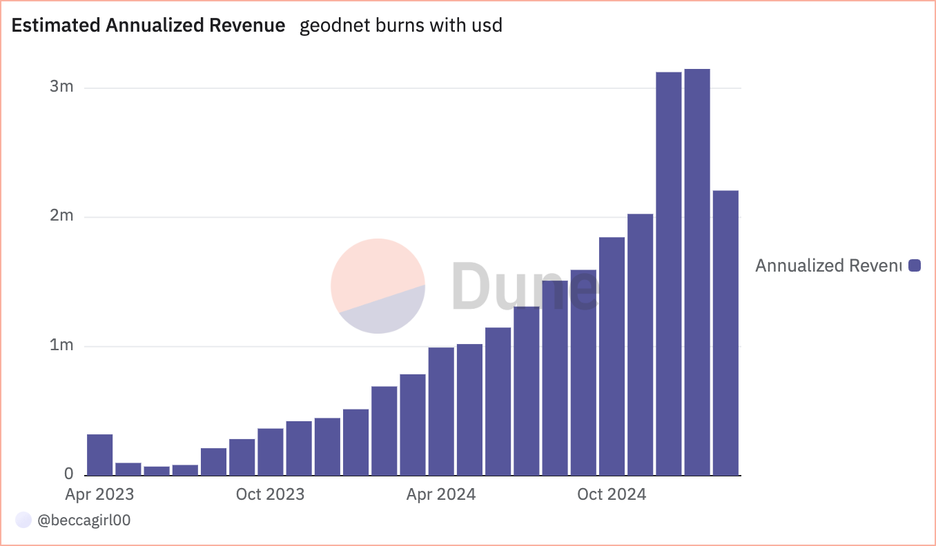
Currently, Geodnet generates approximately $3 million in annualized on-chain revenue by providing services to leading drone companies such as Propeller, DroneDeploy, Quectel, and government agencies like the USDA (United States Department of Agriculture), demonstrating the fastest demand-side growth in the DePIN field.
In early conversations with Geodnet founder Mike Horton, when asked how to attract the world's most influential customers in autonomous driving, drones, and agricultural robotics, his answer remained consistent: the core structural cost advantages brought by the DePIN model.
The Turning Point Has Arrived
In the next decade, robotics technology is expected to experience explosive growth. From industrial manufacturing to daily life, tens of millions of robots are anticipated to be deployed across various fields. Drones will inspect power lines and pipeline facilities from the air, autonomous vehicles will reshape freight and transportation services, smart warehouse robots will massively replace manual operations, and household humanoid robots will gradually enter homes to assist with daily tasks.
Precise positioning capability is the cornerstone of this robotic revolution. Without reliable positioning data, any autonomous robot will struggle to perform its intended functions. For example, in urban canyons with weak GPS signals, autonomous vehicles must rely on RTK-enhanced GNSS systems for safe navigation; delivery drones also require centimeter-level accuracy to land accurately at designated charging stations. Therefore, RTK positioning has become not just a supplement to sensors like LiDAR and RADAR, but a critical infrastructure for robot operation.
Currently, many robotics companies are paying high fees for traditional GNSS correction services each year, yet still face numerous issues such as limited coverage and unstable accuracy. In contrast, Geodnet, through its innovative DePIN model, not only significantly reduces service costs but also provides higher quality positioning services. This groundbreaking solution is attracting an increasing number of enterprise customers, providing reliable positioning support for current and future autonomous robots.
The AI-driven robotic revolution has become an irreversible trend, with the key being the timing of its full explosion. The robotics industry is accelerating its development, and Geodnet's precise positioning network will ensure that these robots can operate safely and efficiently. In the upcoming era of robotics, Geodnet's positioning services will play an irreplaceable role, providing precise and reliable location information support for robots worldwide.
免责声明:本文章仅代表作者个人观点,不代表本平台的立场和观点。本文章仅供信息分享,不构成对任何人的任何投资建议。用户与作者之间的任何争议,与本平台无关。如网页中刊载的文章或图片涉及侵权,请提供相关的权利证明和身份证明发送邮件到support@aicoin.com,本平台相关工作人员将会进行核查。


