Author: @catheryln, JDI Global
(1)Basic Information
Official website: https://geodnet.com/index.html
Twitter: @GEODNET_
GEODNET's mission is to collect dense real-time geospatial data from the Earth and its atmosphere using new rooftop meteorological stations to provide centimeter-level positioning services, including RTK, PPP, PPP-RTK, and future AI-based positioning services.
The use of blockchain will promote a robust and resilient network that provides secure and trusted geospatial data products for key economic sectors such as agriculture, transportation, and finance, as well as emerging applications for Autonomy, AR/VR, and Metaverse.
In July 2023, GEODNET completed a $1.5 million financing round, led by Borderless Capital's Web3 investment fund EdgeFi Fund, with participation from IoTeX and a group of angel investors. The new funds will be used to expand reliable global coverage and develop mobile operating system software tools.
The valuation of this round of financing has not been disclosed, but based on information provided by EV3 earlier, the team's valuation at the time of financing was a post-money valuation of $25 million, raising $5 million in funds. In reality, the valuation may have been adjusted.
(2)Core Business
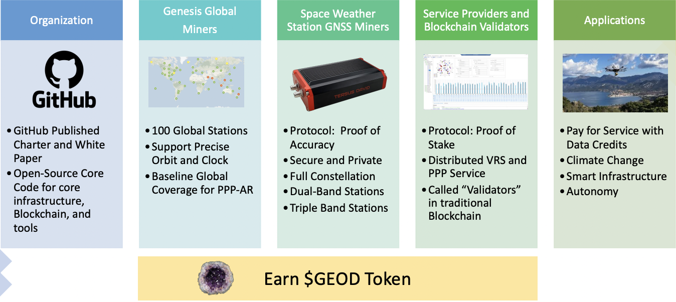
GEODNET uses new receiver technology and the power of blockchain to build a global RTK network and provide centimeter-level positioning services at very low cost, offering a set of **dense measurements** to enjoy economies of scale, reliability, and accuracy.
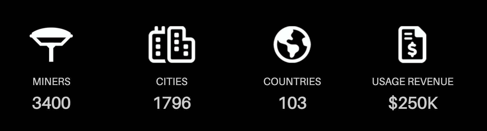
Currently, there are 3400 nodes in the entire network, with 1400 nodes added since the last statistics (February 2023), and over 80% of the nodes can operate stably, mainly distributed in Europe and North America.
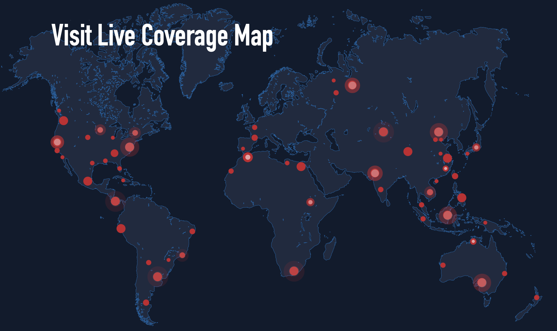
https://console.geodnet.com/map
Infrastructure
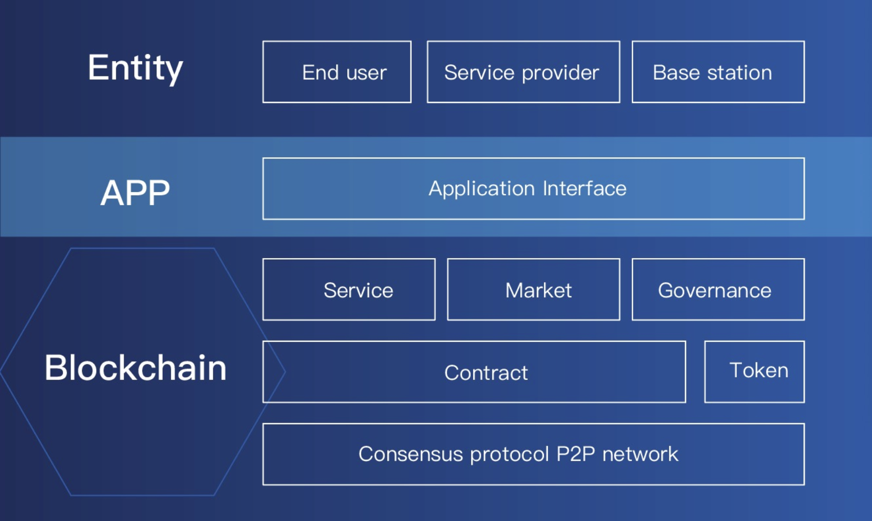
Public chain: GEODNET has built independent L1 and L2 blockchain systems that can support 1000+ TPS. The service module, market module, and governance module are defined as smart contracts in the blockchain, which can execute and monitor in a decentralized manner. GEODNET will provide application interfaces on the blockchain for practical applications such as unmanned aerial vehicles and autonomous driving, allowing users, service providers, base stations, and other entities to interact with the application interface for blockchain operations.
Currently, $GEOD is issued on Polygon, and it is uncertain whether an independent blockchain will be built to support network operations.
Consensus mechanism: POA+POS+POL consensus protocol, where POA refers to proof of accuracy, POL refers to proof of location, and POA is an important criterion for verifying the eligibility of nodes. GEODNET's hardware supports precise positioning requirements. POA will judge the operation of mining machines based on parameters such as the quantity and quality of signals emitted by the mining machines, the location of meteorological stations, and effective online time, and allocate profits. After receiving a series of successful validation messages within a time threshold t _validation, the initial GNSS Miner validation will occur, a process known as proof of location. If validation is not provided in a timely manner, GNSS Miners will become invalid and be removed from GEODNET.
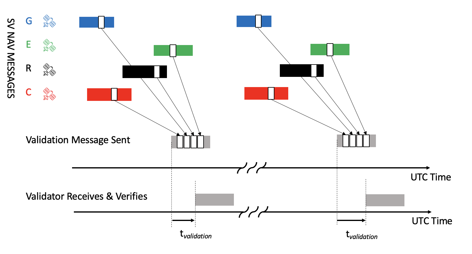
proof of location validation messages
Smart contract system: GEODNET has introduced a smart contract enablement system for DeFi and emerging geolocation applications.
Core Technology
- Real-time Kinematic (RTK) GNSS
The HYFIX positioning products and algorithms provide centimeter-level accuracy for traditional measurements, new IoT applications, and mobile devices.
- Remote correction via LoRa network
Optional LoRaWAN wireless gateways allow remote radio distribution of RTCM corrections without internet access.
- Precise positioning through sensor fusion
Using sensor fusion of IMU, GNSS, and other sensor data, the HYFIX algorithm can provide precise positioning in challenging GPS environments.
(3)Products
Hardware Products (C-end, mining, network construction)
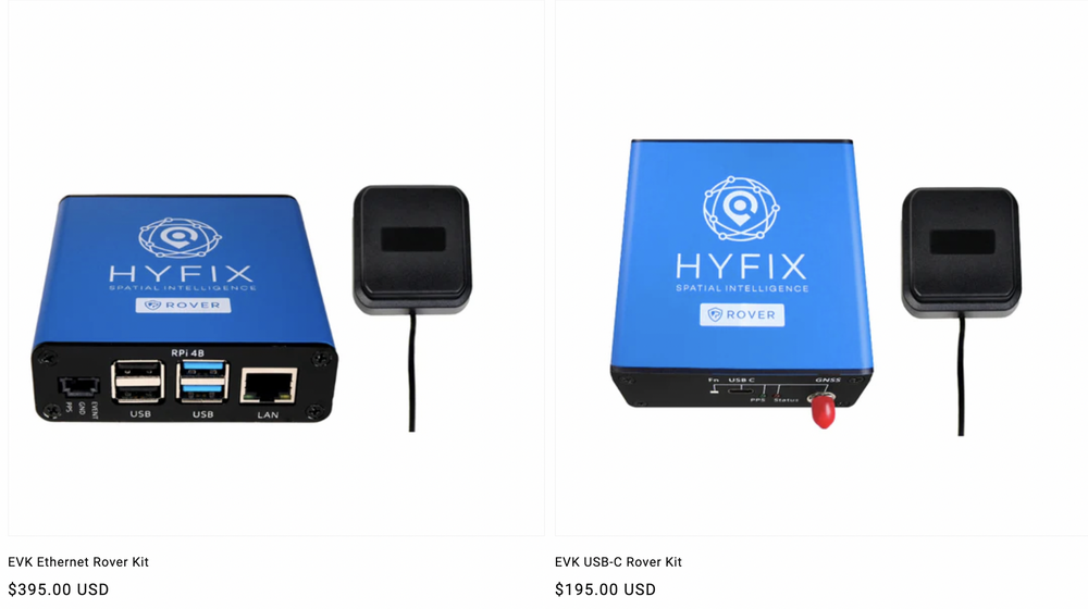
Currently, GEODNET mainly has three hardware products, sold through a direct sales platform and three distribution platforms: HYFIX.AI (direct sales), EUGEO, CryptoStation, TechnoStoreX. In addition, in January of this year, ROCK Robotic announced the launch of the 1,400-channel three-frequency RTK base station ROCK Base, but the product has not yet been officially launched.
The latest price of the dual-band base station is $395, a $100 decrease compared to the previous statistics
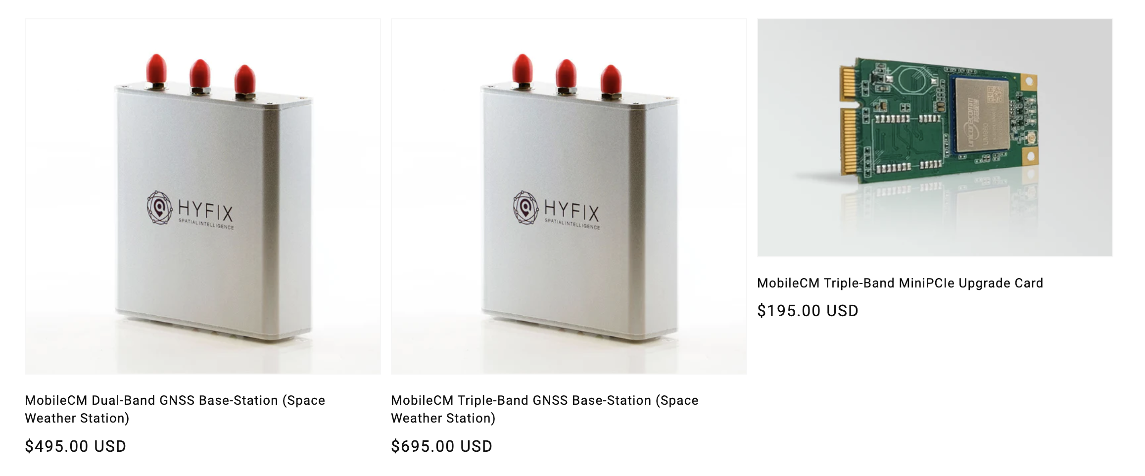
In addition, hyfix.ai recently launched GEODNET-compatible receivers as follows.
The MobileCM Dual-Band/Triple-Band is a high-quality GNSS base station available at any time, which can be used as an RTK base station and collect spatial weather data. The dual-band version taps into two key GNSS frequencies—the primary L1 signal and the modern L5 signal (used for the latest smartphones)—as well as variants of international constellation signals across a total of 6 frequency bands. The triple-band version taps into all three major GNSS frequencies L1, L2, and L5, including all international constellation signal variants across a total of 12 frequency bands. This device connects to GEODNET via Wi-Fi.
The MobileCM Triple-Band MiniPCIe upgrade card can easily upgrade the dual-band MobileCM base station to operate in triple-band mode, effectively doubling the potential tracking frequency bands from 6 to 12, thereby earning double rewards like dual-band miners.
Solutions (B-end, network application layer, cost advantage)
HYFIX develops IoT-friendly low-cost embedded software and hardware solutions for centimeter-level GNSS. The MobileCM and EmbedCM product lines use the latest dual-frequency GNSS chipsets. HYFIX also manufactures plug-and-play GEODNET base stations and supports RTK and PPP algorithms using GEODNET data streams.
(4)Problems Solved
GEODNET aims to establish a decentralized global CORS reference station system through web3 economic incentives.
The full name of CORS reference station system is the Continuously Operating Reference Station (CORS) system, which can be defined as one or several fixed, continuously operating GNSS reference stations. It uses a network composed of modern computers, data communication, and internet (LAN/WAN) technology to automatically provide verified GPS observations (carrier phase, pseudorange), various corrections, status information, and other related GPS service items to users of different types, needs, and levels in real time through GSM/GPRS wireless phones or the internet.
For example, in China, regional CORS station construction has established urban service systems in cities such as Beijing, Hong Kong, Shanghai, Shenzhen, Tianjin, Wuhan, Kunming, and Chengdu. Except for Tibet, 30 provinces have completed or are in the process of building continuous satellite positioning comprehensive service systems covering the entire province, and some provincial and municipal reference station networks have begun to provide services to the public. According to the latest national reference station survey, there are approximately 4500 reference stations constructed by various industries in various regions.
The provincial (municipal) systems mainly play a role and have advantages in the following areas: they can significantly improve surveying accuracy and efficiency in control surveying, engineering surveying, and municipal pipeline surveying, reducing surveying labor intensity and costs. They can achieve real-time, effective, long-term deformation monitoring, playing an important role in disaster early warning. In many areas of the city, such as meteorology, vehicle and ship navigation positioning, object tracking, public security and fire protection, surveying, GIS applications, they can provide high-precision, real-time dynamic navigation positioning services. They have become an important part of urban informatization, providing a three-dimensional, dynamic, geocentric coordinate reference framework for urban spatial infrastructure.
Currently, many developed countries have established relatively complete CORS systems. Representative examples include the CORS system in the United States, the CORS system in Germany (SPAOS), the CORS system in Japan (COSMOS), and the CORS system in Australia.
The earliest CORS system was the CORS system in the United States, established in the early 1990s. It was led by the National Geodetic Survey (NGS) of the United States. The initial plan was to establish 250 reference stations, with distances of 100-200 km between the stations, covering the entire country.
Notably, the SPAOS system in Germany is a continuous satellite navigation positioning service system jointly established by the German surveying management department and departments of transportation, construction, real estate management, and defense. The system consists of more than 250 permanent reference stations, with an average distance of 40 km between stations. The system can provide four different levels of positioning services with different accuracies: real-time positioning service, high-precision real-time positioning service, precise geodetic positioning service, and high-precision geodetic positioning service.
The Geospatial Information Authority of Japan began deploying a crustal strain monitoring network in the early 1990s, which gradually developed into the Japanese GPS Continuous Strain Monitoring System (COSMOS). Japan has the largest and most densely distributed number of CORS stations, with distances of only 10-15 km between reference stations. This system is an important foundational infrastructure in Japan.
The proposal of GEODNET is based on the project team's belief in the problems of traditional CORS systems:
- Slow expansion speed
- High maintenance costs
- Expensive prices
- Regional limitations, unable to be used across regions
- Poor performance, low security, and limited application support
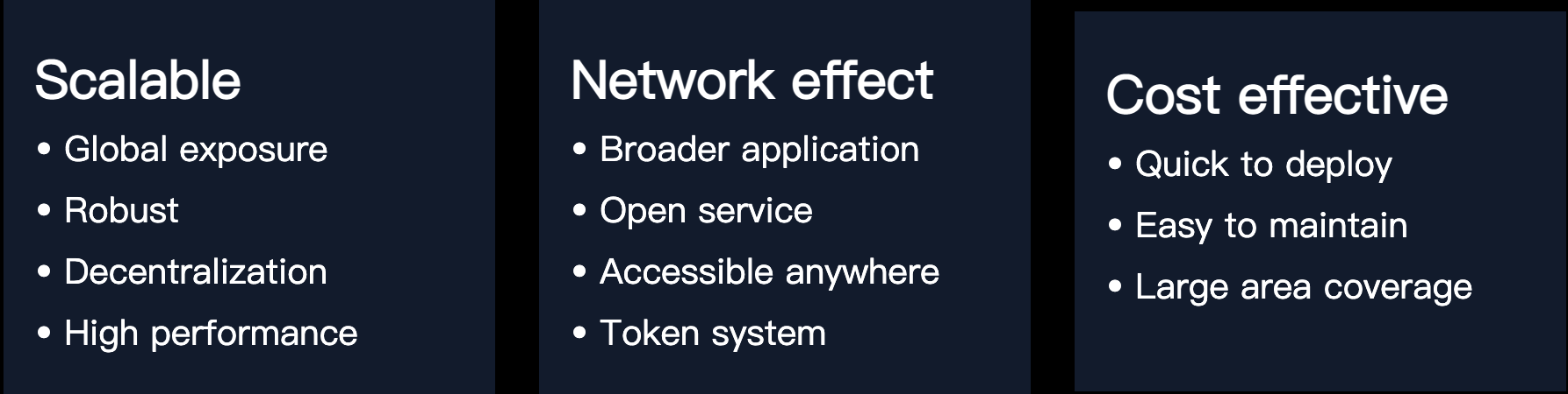
GEODNET effectively addresses the shortcomings of traditional CORS systems by combining blockchain technology and the economic incentive model of web3, forming stronger network effects and cost benefits.
(5)Tokens
GEODNET adopts a dual-token mechanism, with Data Credits as the utility token. Miners need to consume Data Credits when connecting mining machines to the network, and users need to pay Data Credits when purchasing data or accessing services. The price of 1 Data Credit is fixed at $0.00001.
- Mining machines consume Data Credits over time when connected to the network, at a rate of 1 Data Credit per second.
- Users who wish to access services from GEODNET also need to pay Data Credits. Continuous use of GEODNET for one hour requires a payment of $0.036, and continuous use for one year requires a payment of $315.
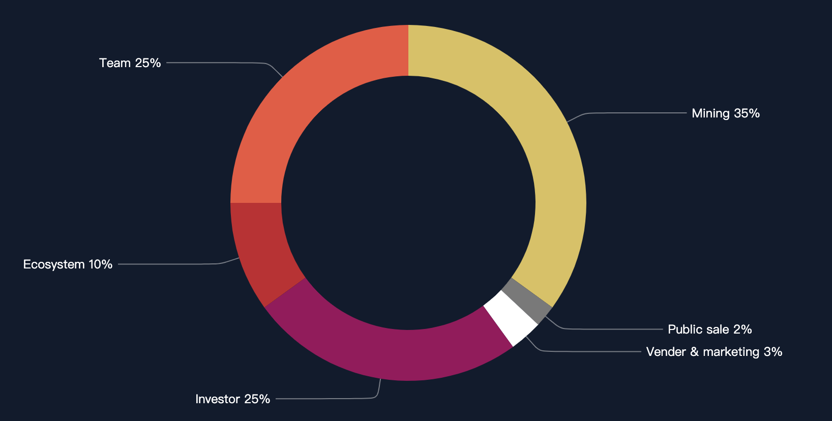
$GEOD serves as the governance token, which can be obtained through mining. The total supply is 1 billion tokens. GEODNET will issue pre-mined tokens on Polygon, with a 3-year vesting period for tokens belonging to the team, investors, and the ecosystem.
| Token Information GEOD | |
|---|---|
| Price | $0.046 |
| Exchange | Uniswap, QuickSwap |
| 24H Trading Volume | $6687 |
| FDV | $46.19 million |
| Public Chain | Polygon |
| Listing Date | 2022-08 |
| Total Supply | 1 billion tokens |
(6)Team
GEODNET is headquartered in California, USA, with a current team size of around 10 people. Core members include:
Yudan Yi
As one of the top experts in his field, Yudan previously served as Senior Director at Aceinna. Prior to that, he was a research scientist at Qianxun SI. Before that, he was a Senior Research Scientist at Topcon Positioning Systems. He holds a Ph.D. from Ohio State University and a master's degree from Tongji University.
David Chen
David Chen is a seasoned technology leader with over 20 years of experience in Silicon Valley. Since 2013, as a blockchain pioneer, he has been a full-stack blockchain expert, covering consensus protocols, networks, security, and smart contracts and DAPPs. David is a co-founder of several blockchain projects including Jingtum Tech and Moac Blockchain.

Mike A. Horton
As a successful entrepreneur, Horton co-founded Crossbow Technology in 1995 and served as CEO until the company was acquired by Moog Inc. in 2011. Since then, Mike has co-founded several venture companies. He holds a Bachelor's and Master's degree in Electrical Engineering from the University of California, Berkeley.
(Seven)Ecosystem and Dynamics
Stakeholders
Governance: GeoDAO is responsible for distributing critical source code and technical documentation, driving the project, organizing review and improvement proposals (GIP).
Miners: There are currently 3400 miners, and two space weather stations have been launched for sale.
Validators: Validators can stake tokens to become validators and earn token rewards. Validators can access and process data from global/regional space weather stations, process transactions, allocate data streams, etc. Since validators also need to provide data services to end users, they typically require high-performance servers, similar to the role of Helium validators.
Application Layer: Paid services can be provided in areas such as climate change monitoring, autonomous driving, high-resolution mapping, autonomous construction, drone logistics, unmanned farms, VR/AR, geodesy, and deformation monitoring.
Recent Developments
The IoTeX ecosystem announced the addition of 4 DePIN projects, including @dropwireless, @AYDO_AI, @XNET_Mobile, and @GEODNET_. According to current information, they will use the w3bstream tool for DePIN construction.
The decentralized global Earth observation network @GEODNET_ will halve its network-wide rewards on June 30, with the network currently having 3,259 nodes.
At the FIRA International Agricultural Robotics Forum, GEODNET announced the preliminary availability of real-time kinematics (RTK), centimeter-precision, GNSS correction services for original equipment manufacturers (OEMs) and system integrators. GEODNET is compatible with thousands of on-site GNSS receivers, vehicle automatic steering and spraying kits from all major brands, as well as the latest drones and robots. The dense reference station network provides fast, reliable performance and achievable best accuracy. Now, qualified OEMs and system integrators in most major agricultural regions globally can trial GEODNET correction services for free.
https://geodnet.com/geodenet-announces-RTK-centimeter-precision-gnss-corrections-service.html
ROCK Robotic announced the launch of the 1,400-channel three-frequency RTK base station ROCK Base.
(Eight)Roadmap
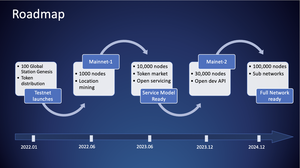
Based on the roadmap released in the project whitepaper, as of the current time, the project has launched mainnet 1 and has deployed at least 1000 global space weather stations (currently over 2000 weather stations), including 100 genesis weather stations during the testnet phase. By June 2023, the network is expected to reach 10,000 nodes, and an open service platform will be launched, indicating protocol revenue creation at the application layer. By the end of 2023, the project will launch mainnet 2, with the network expected to increase to 30,000 nodes. After the full launch of the mainnet, the project will introduce subnetworks following the model of Helium, and plans to complete the construction of subnetworks by the end of 2024, with an expected total network of 100,000 nodes at that time.
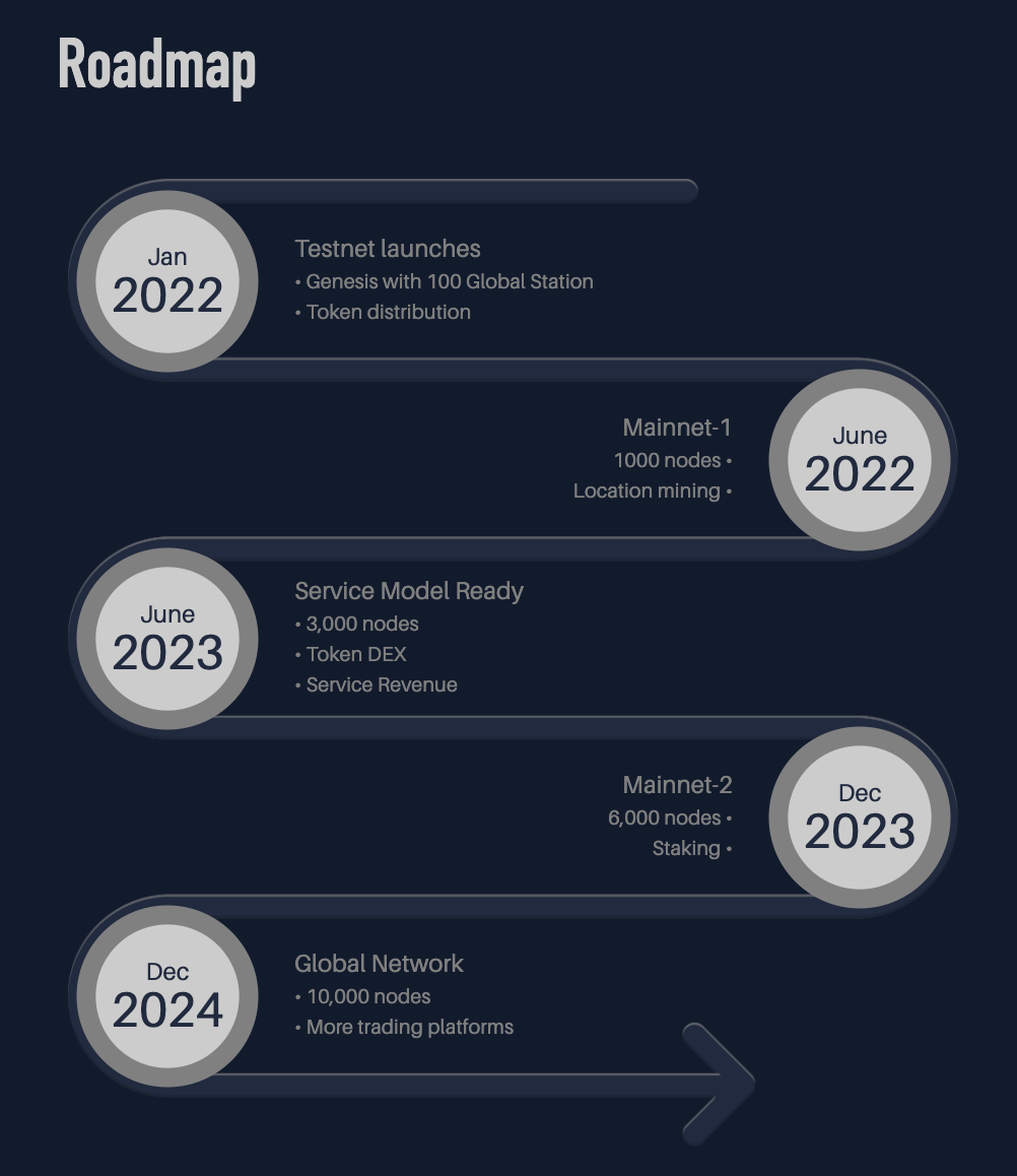
Based on the updated roadmap, the node development has not followed the team's initial plan. As of now, there are 3400 nodes in the network, lower than the team's target of reaching 10,000 nodes by June of this year. In the latest roadmap, the team still plans to launch testnet 2 and introduce staking by the end of this year, with an expected network node count of 6,000 at that time. Additionally, the team has made changes to the subnetwork roadmap, with no specific plans for subnetworks in the latest roadmap. The long-term plan of the team has shifted to establishing a trading platform.
(Nine)Earnings and Payback Period
Miner Earnings in GEODNET
GEODNET requires miners to optimize the deployment of their mining machines as much as possible to maximize earnings.
- Regarding the calculation of miner earnings, miner earnings are mainly related to effective satellite no. The specific calculation method can be seen in the following document. In summary, miners should strive to have an effective satellite no > 30 to maximize their earnings.
- It is worth mentioning that to reward early participants, GEODNET has issued location NFTs. Miners with a reward ratio of over 98% for a specified period can receive location NFTs. Each hex has only one location NFT, and holders of location NFTs can enjoy a permanent 100% reward ratio.
Geodnet_Reward_token_with_the_consideration_of_Satellite_No_220630.pdf
Geodnet_Token_Reward_with_Satellite_SNR_220926.pdfPayback Period Calculation
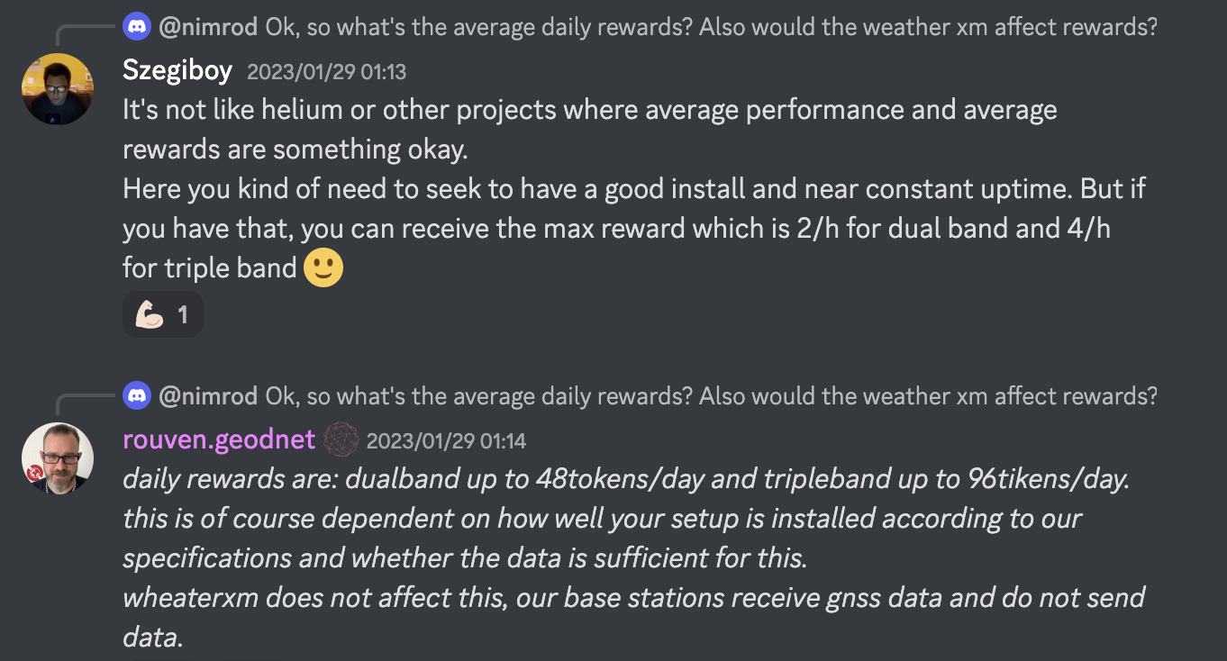
GEODNET website does not have statistical data on miner earnings, but community information indicates that well-deployed mining machines can earn a maximum of $48 GEOD (dual-band) and $96 GEOD (triple-band) per day.
Based on the current GEOD transaction price, the payback period is calculated as follows:
| Miner Type | Miner Price | Coin Price | Daily Earnings | Payback Period |
|---|---|---|---|---|
| Dual-Band | 395USD | 0.046USD | 2.208 | 6 Months |
| Triple-Band | 695USD | 0.046USD | 4.416 | 5 Months |
Note: The historical high/low price of GEOD is 0.082/0.009USD.
The above is a theoretical estimate. According to statistics from depinscan, the average daily earnings are approximately $1.01, with an average payback period of about 18 months.
(Ten)Protocol Revenue of GEODNET
GEODNET's machine production and sales are handled by third parties, and the project's revenue mainly comes from data sales. From the end of 2022 to February 2023, GEODNET generated $120,000 in revenue through data sales. However, this revenue mainly comes from global base stations, which are space stations planned, deployed, and managed by Hyfix. Compared to stations operated solely by users, global base stations have more professional construction conditions and data collection levels.
https://hyfix.ai/pages/global-stations
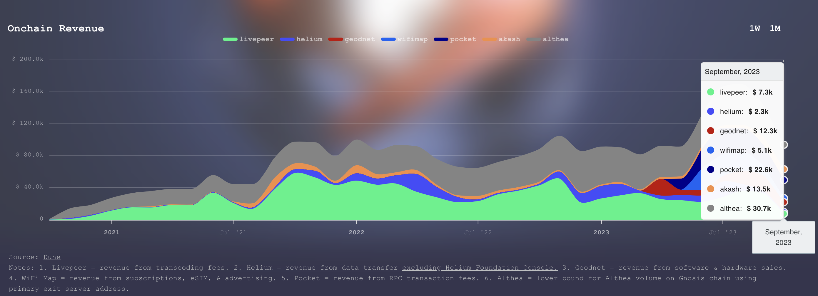
According to statistics from depin.ninja, GEODNET's on-chain revenue in September 2023 was $12.3k USD, which comes from software and hardware sales. Compared to other depin projects, GEODNET's revenue consistently ranks in the upper-middle level.
(Source)
[1]https://cloud.tencent.com/developer/news/79622
[2]https://blog.csdn.net/u010783226/article/details/123446656
[3]https://www.qxwz.com/zixun/365266704
[4]https://www.sinognss.com/news/1637.html
免责声明:本文章仅代表作者个人观点,不代表本平台的立场和观点。本文章仅供信息分享,不构成对任何人的任何投资建议。用户与作者之间的任何争议,与本平台无关。如网页中刊载的文章或图片涉及侵权,请提供相关的权利证明和身份证明发送邮件到support@aicoin.com,本平台相关工作人员将会进行核查。


